Tree Inventory AI

Features

Everything you need to inventory trees professionally — from capture to report. AI handles the data entry so you can focus on the trees.

Works alongside your existing CRM or field service software
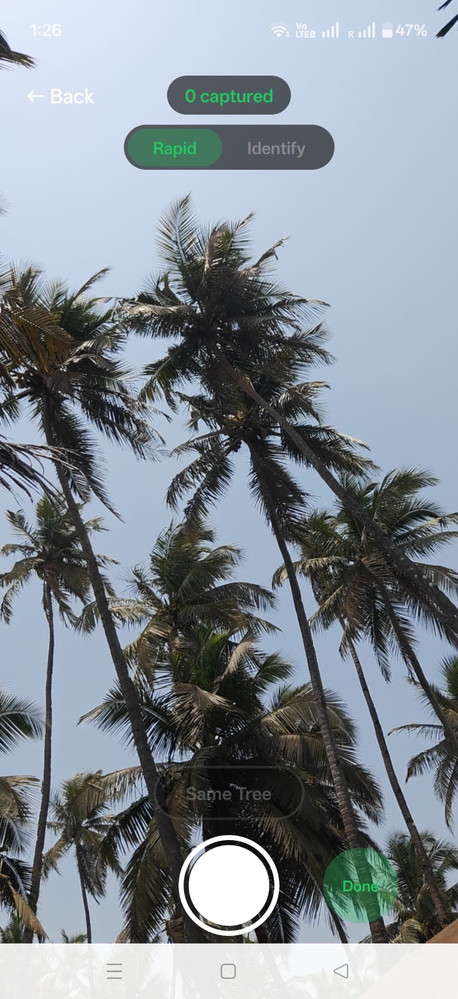
Capture

10 seconds per tree. GPS, photos, and context — captured as you walk.
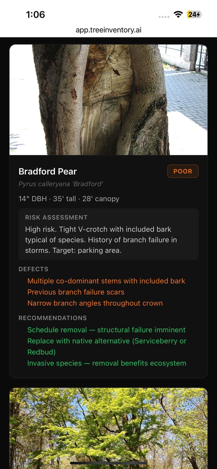
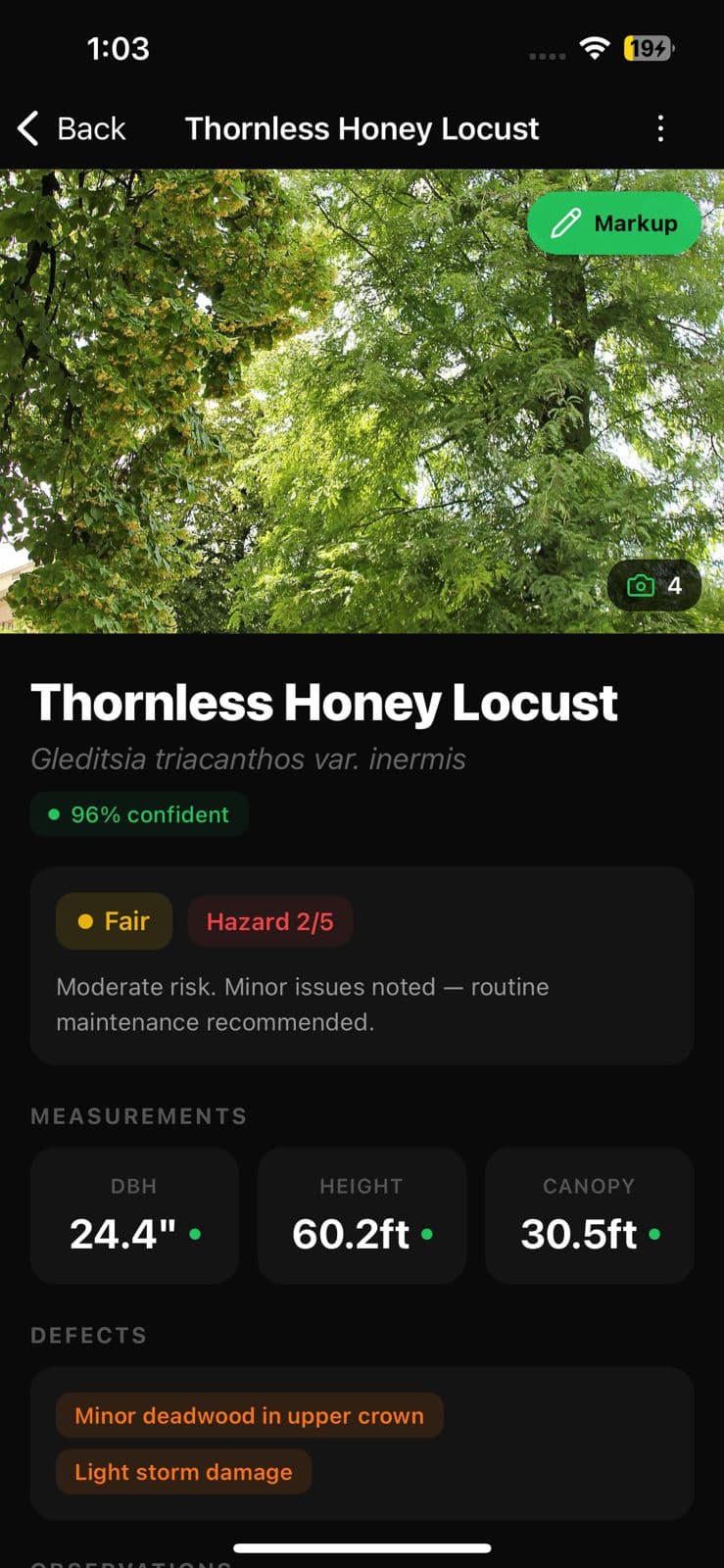
Tree inventory mobile app — rapid photo capture viewfinder pointed up at a palm canopy with live GPS pin overlay

Rapid Photo Capture

Snap a photo of any tree and capture species, size, and condition in under 10 seconds. No typing, no clipboards.

GPS Auto-Tagging

Every tree is automatically pinned with GPS coordinates. Build a property map as you walk the site.

Voice Notes

Hold to talk on any tree. Whisper transcribes, Claude sorts your words into health notes, recommendations, and client context.

Multi-Photo Per Tree

Capture trunk, canopy, root flare, and defects. Multiple angles give the AI more data and give your reports more detail.

Live Inference Preview

While you frame the shot, the app guesses species and DBH so you know whether to step closer. Confirms or corrects on capture.

AI Analysis

Computer vision that sees what the clipboard misses.
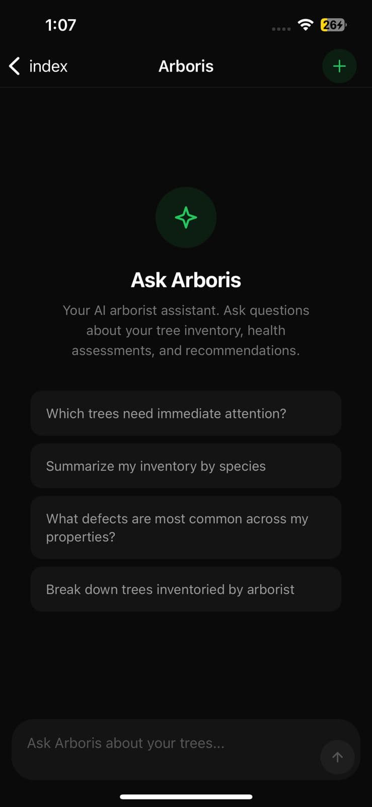
AI tree species identification on iPhone — Eastern Red Cedar identified at 96% confidence with estimated DBH, height, and canopy spread

Species Identification

Computer vision identifies species from bark, leaf, and form photos. Confidence scores let you verify. Thousands of species supported.

Measurement Estimation

AI estimates DBH (trunk diameter), height, and canopy spread from photos. Review and correct with one tap — the AI learns from your corrections.

Health Condition Grading

Automated health assessment: Good, Fair, Poor, Dead, or Hazardous. AI detects disease symptoms, pest damage, deadwood, and stress indicators.

Risk & Hazard Scoring

1-10 hazard ratings based on structural condition, target zone, species risk factors, and defect severity. Flag dangerous trees instantly.

AI Service Recommendations

Per-tree action plan — prune, remove, monitor, fertilize, cable — priority-ranked with reasoning. Drops straight into the report.

Arboris AI Engine

Ask questions about your trees. Get answers backed by your inventory data.
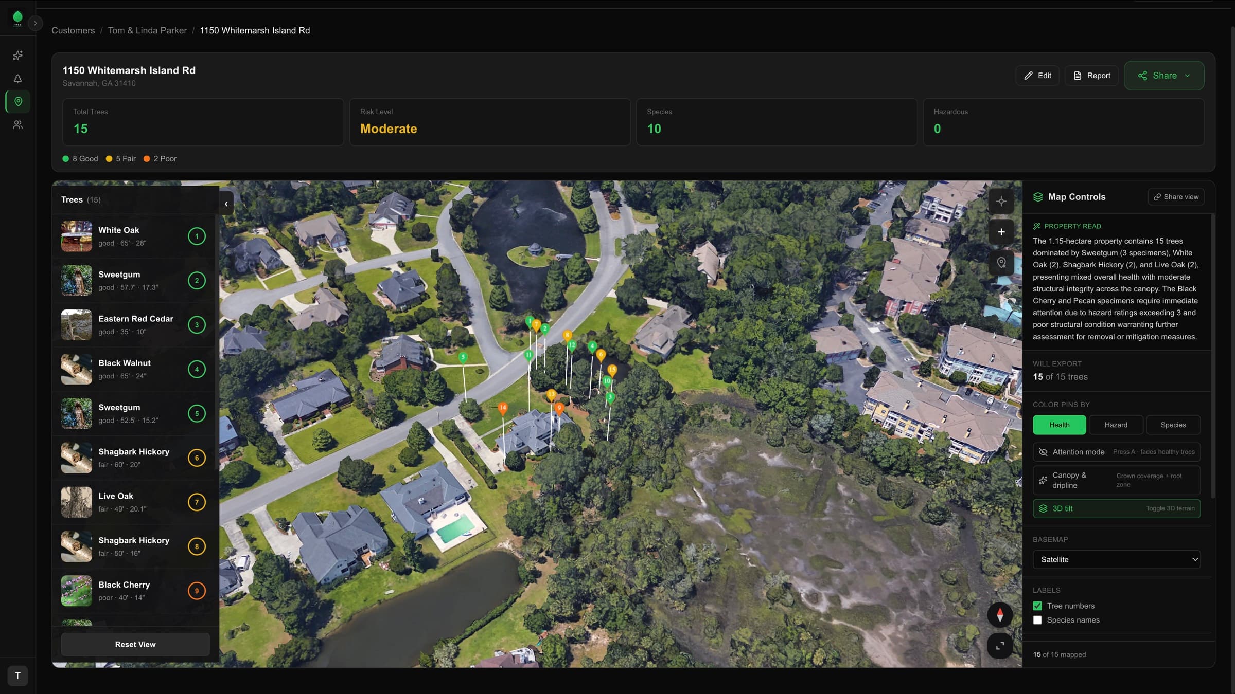
Arboris AI arborist assistant streaming a tree-inventory answer, citing specific trees by species and location

Natural Language Questions

Ask Arboris anything about your inventory: "Which trees need immediate attention?" "Summarize my inventory." "Show me all trees with poor health." Get answers backed by your real data.

Inventory-Aware Reasoning

Arboris analyzes your actual tree data — species, health, measurements, risk scores, and recommendations — across all your properties. Every answer cites specific trees by name and location.

Customer & Property Context

Responses include customer names, property addresses, and tree-level detail. No generic answers — everything is grounded in your inventory data.

Streaming Responses

Watch Arboris reason in real time. Intent classification, data analysis, and response generation streamed to you as it happens. Full conversation history with thread management.

Property Map & GIS

Every tree on every property — mapped, color-coded, and shareable.

Tree inventory GIS dashboard — 1150 Whitemarsh Island Road property with 15 health-color-coded GPS pins on a satellite map, species sidebar, and AI-generated property brief

Property Map View

Every tree on every property pinned on a satellite map and color-coded by health, hazard, or species. Toggle modes with one tap. Share with clients via a public link.

3D Property Walkthrough

Tilt into an interactive 3D model of the property. Click any pin for species, condition, and recommendations. Shareable so clients can explore remotely.

Bulk Pin Adjust

Drag pins to refine GPS positions on a 2D satellite view. Each drop auto-saves — no manual save button. Fast cleanup when GPS drift puts a tree on the wrong side of the driveway.

AI Property Brief

Auto-generated summary of every property: tree count, species mix, dominant condition, and standout risks. Reads like a paragraph from a senior arborist.

Public Share Link

Toggle a property public and send the URL. Your client opens the map on any phone — no login, no app install, no PDF attachment.

Output & Reporting

Professional deliverables generated from your captured data.

Arborist property inventory PDF report — annotated tree page with measurements, defects, and prioritized recommendations

Professional PDF Reports

One-tap property inventory reports with species summary, risk matrix, GPS map, annotated photos, and recommended actions.

AI Narrative Writeup

A written property assessment in plain English, generated from your inventory. Drop it into a proposal, an email, or an expert-witness package.

Photo Markup & Annotation

Draw arrows, circles, and text on photos to document defects. Annotations carry into reports automatically.

CSV Export

Export full inventory data as CSV for import into your CRM, GIS software, or spreadsheets.

GeoJSON Export

Download the full property as GeoJSON for ArcGIS, QGIS, or any GIS pipeline you already run.

Job Site Photos & Recordings

Attach standard job site photos and audio recordings to any property. Context beyond individual trees — document the full site.

Ready to see it in action?

Pro is free for the first 100 arborists. No card required.